


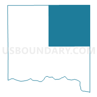
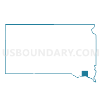
VTD-precinct 14, Yankton County, South Dakota
About
Outline

Summary
| Unique Area Identifier | 667860 |
| Name | VTD-precinct 14 |
| County | Yankton County |
| State | South Dakota |
| Area (square miles) | 144.59 |
| Land Area (square miles) | 144.35 |
| Water Area (square miles) | 0.24 |
| % of Land Area | 99.83 |
| % of Water Area | 0.17 |
| Latitude of the Internal Point | 43.07580670 |
| Longtitude of the Internal Point | -97.28527970 |
Maps

Graphs
Select a template below for downloading or customizing gragh for VTD-precinct 14, Yankton County, South Dakota


Neighbors
Neighoring Voting District (by Name) Neighboring Voting District on the Map
- VTD precinct 1, Hutchinson County, SD
- VTD-precinct 16 JamesvilleTwp, Yankton County, SD
- VTD-precinct 19 CentralTwp, Yankton County, SD
- VTD-precinct 22 VolinTwp, Yankton County, SD
- VTD-precinct 23 MissionHillTwp, Yankton County, SD
- VTD-precinct 24 UticaTwp, Yankton County, SD
- VTD-precinct 4, Turner County, SD
- VTD-precinct 6, Turner County, SD
- VTD-precinct 7, Turner County, SD
- VTD-precinct W02, Clay County, SD
Top 10 Neighboring County Subdivision (by Population) Neighboring County Subdivision on the Map
- West Yankton UT, Yankton County, SD (3,474)
- Utica township, Yankton County, SD (859)
- Mission Hill township, Yankton County, SD (386)
- Volin township, Yankton County, SD (233)
- Jamesville township, Yankton County, SD (232)
- Irene city, Turner County, SD (231)
- Swan Lake township, Turner County, SD (209)
- Daneville township, Turner County, SD (207)
- Mayfield township, Yankton County, SD (206)
- Spring Valley township, Turner County, SD (193)
Top 10 Neighboring Place (by Population) Neighboring Place on the Map
Top 10 Neighboring Unified School District (by Population) Neighboring Unified School District on the Map
- Yankton School District 63-3, SD (20,134)
- Irene-Wakonda School District 13-3, SD (2,024)
- Menno School District 33-2, SD (1,536)
- Viborg School District 60-5, SD (1,419)
- Gayville-Volin School District 63-1, SD (1,030)
Top 10 Neighboring State Legislative District Lower Chamber (by Population) Neighboring State Legislative District Lower Chamber on the Map
- State House District 18, SD (22,438)
- State House District 17, SD (20,551)
- State House District 19, SD (19,075)
Top 10 Neighboring State Legislative District Upper Chamber (by Population) Neighboring State Legislative District Upper Chamber on the Map
- State Senate District 18, SD (22,438)
- State Senate District 17, SD (20,551)
- State Senate District 19, SD (19,075)
Top 10 Neighboring 111th Congressional District (by Population) Neighboring 111th Congressional District on the Map
Top 10 Neighboring Census Tract (by Population) Neighboring Census Tract on the Map
- Census Tract 9652, Turner County, SD (4,200)
- Census Tract 9664, Yankton County, SD (3,807)
- Census Tract 9686, Hutchinson County, SD (3,153)
- Census Tract 9658, Clay County, SD (2,897)
Top 10 Neighboring 5-Digit ZIP Code Tabulation Area (by Population) Neighboring 5-Digit ZIP Code Tabulation Area on the Map
- 57078, SD (19,121)
- 57070, SD (1,387)
- 57045, SD (996)
- 57037, SD (819)
- 57073, SD (711)
- 57046, SD (626)
- 57072, SD (584)
- 57067, SD (537)